2021年(令和3年)から飯田橋駅西口駅舎の1階に「史跡紹介解説板」、2階には「史跡眺望テラス」と「史跡紹介解説板」ができています(ここでは史跡紹介パネルとしてまとめています)。
1階の中型パネル4枚(1、2、3、4)のうち3枚目は「外堀の工事方法」で、牛込から赤坂まで、外堀の工事方法の説明です。
工事方法
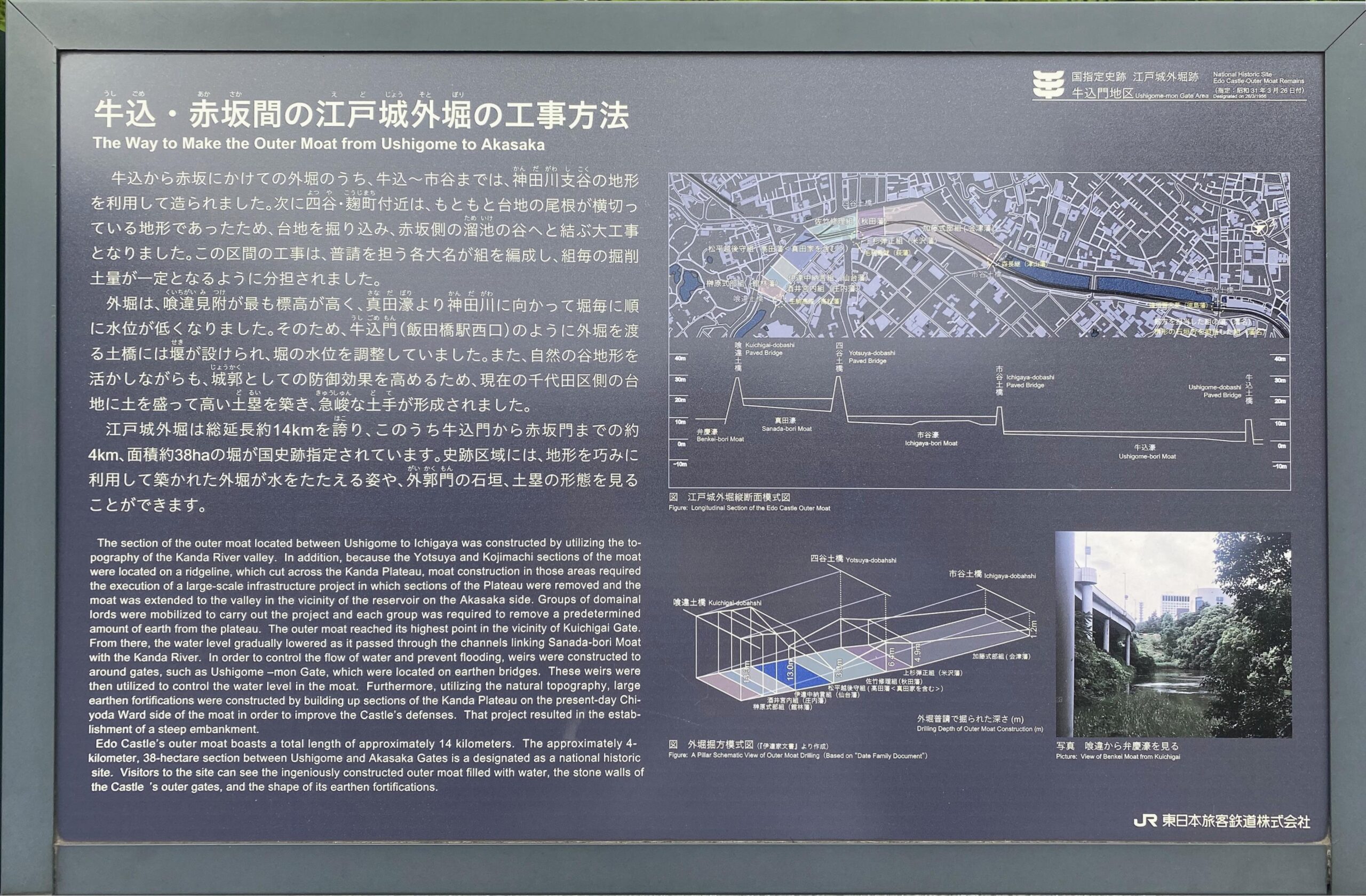
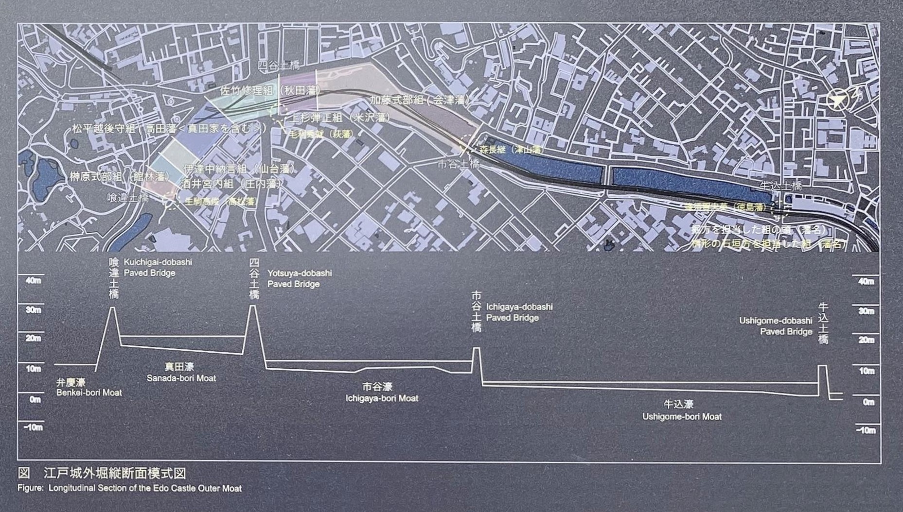
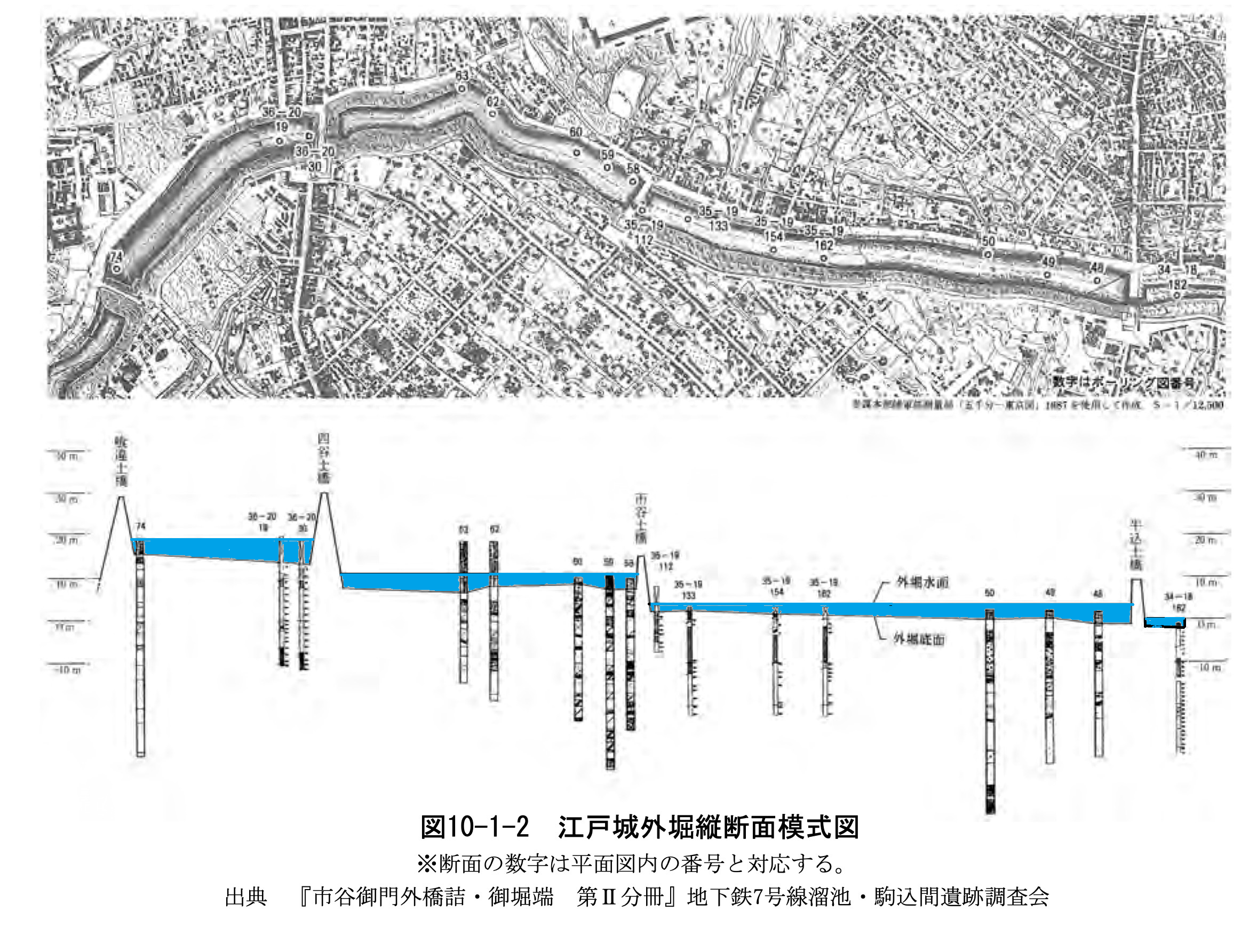
| 牛込・赤坂間の江戸城外堀の工事方法 The Way to Make the Outer Moat from Ushigome to Akasaka 牛込から赤坂にかけての外堀のうち、牛込~市谷までは、神田川支谷の地形を利用して造られました。次に四谷・麹町付近は、もともと台地の尾根が横切っている地形であったため、台地を掘り込み、赤坂側の溜池の谷へと結ぶ大工事となりました。この区間の工事は、普請を担う各大名が組を編成し、組毎の掘削土量が一定となるように分担されました。 |
土橋 どばし。城郭の構成要素の一つで、堀を掘ったときに出入口の通路部分を掘り残し、橋のようにしたもの。転じて、木などを組んでつくった上に土をおおいかけた橋。水面にせり出すように土堤をつくり、横断する。牛込御門の場合は土橋に接続した牛込橋で濠と鉄道を越える。つちばし。牛込門。
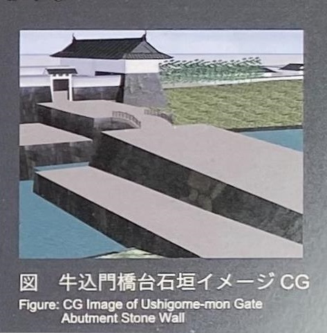
牛込門橋台石垣イメージ
堰 せき。川の途中や流出口などに設けて、農業用水・工業用水・水道用水などの水を川からとるなどのため、水位を制御する施設。ダムや堤防の機能はない。
城郭 城と外囲い。堀や土塁・石垣などにより,外敵の攻撃を防いだ施設。
土塁 どるい。土居。敵や動物などの侵入を防ぐため、主に盛土による堤防状の防壁施設。土を盛りあげ土手状にして、城郭などの周囲に築き城壁とした。英語ではembankmentで、土手、堤防、盛り土などがその訳語。
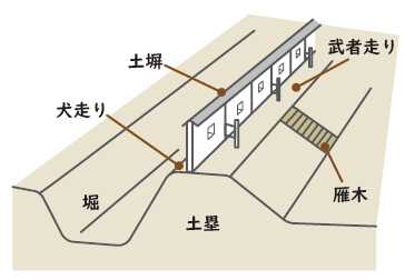
土手 川などがあふれて田地や家屋に流入するのを防ぐために、土を小高く積み上げて築いた長い堤
外郭門 城などの外囲いにある門
| The section of the outer moat located between Ushigome to Ichigaya was constructed by utilizing the topography of the Kanda River valley. In addition, because the Yotsuya and Kojimachi sections of the moat were located on a ridgeline, which cut across the Kanda Plateau, moat construction in those areas required the execution of a large-scale infrastructure project in which sections of the Plateau were removed and the moat was extended to the valley in the vicinity of the reservoir on the Akasaka side. Groups of domainal lords were mobilized to carry out the project and each group was required to remove a predetermined amount of earth from the plateau. The outer moat reached its highest point in the vicinity of Kuichigai Gate. From there, the water level gradually lowered as it passed through the channels linking Sanada-bori Moat with the Kanda River. In order to control the flow of water and prevent flooding, weirs were constructed to around gates, such as Ushigome-mon Gate, which were located on earthen bridges. These weirs were then utilized to control the water level in the moat. Furthermore, utilizing the natural topography, large earthen fortifications were constructed by building up sections of the Kanda Plateau on the present-day Chiyoda Ward side of the moat in order to improve the Castle’s defenses. That project resulted in the establishment of a steep embankment. Edo Castle’s outer moat boasts a total length of approximately 14 kilometers. The approximately 4-kilometer, 38-hectare section between Ushigome and Akasaka Gates is a designated as a National Historic Site. Visitors to the site can see the ingeniously constructed outer moat filled with water, the stone walls of the Castle’s outer gates, and the shape of its earthen fortifications. |
工事方法➀
見附の水位が違う
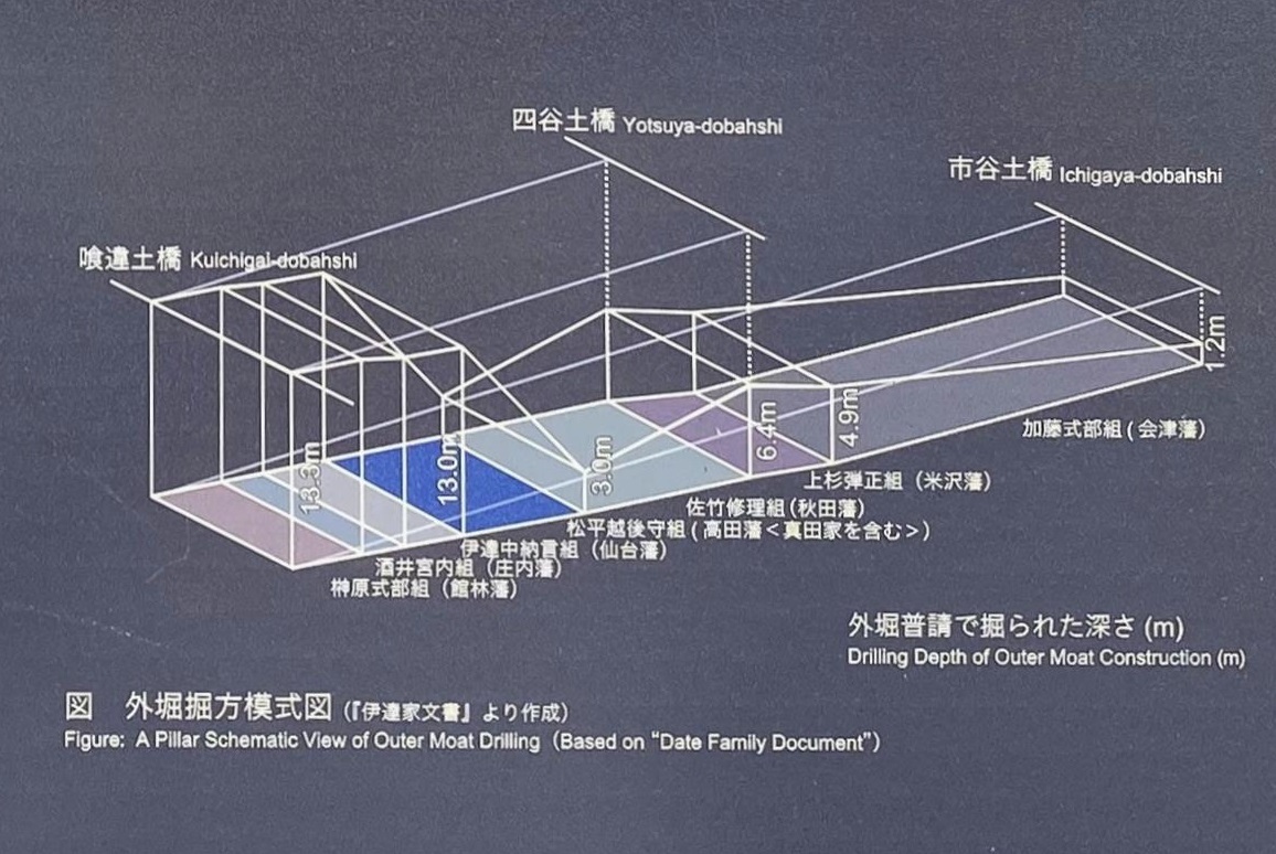
工事方法②
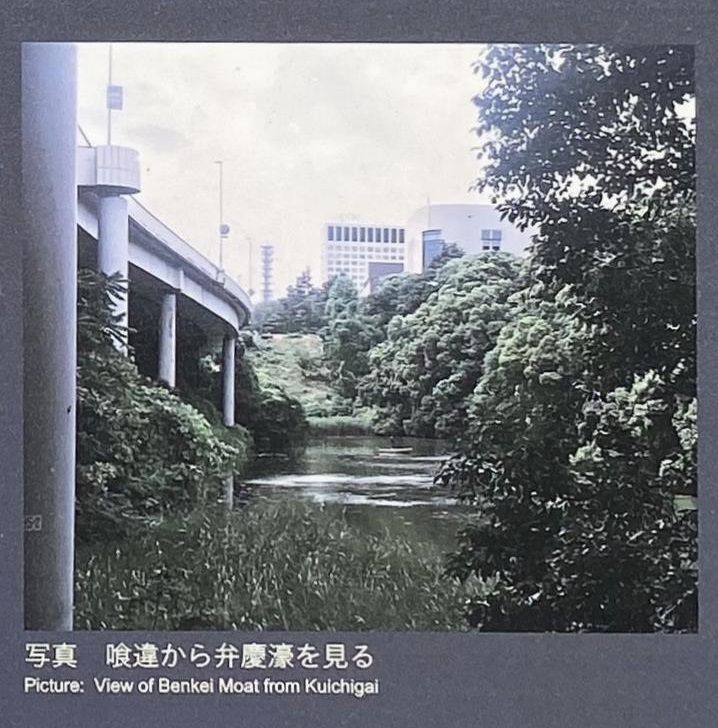
喰違から弁慶濠を見る
野中和夫編「石垣が語る江戸城」(同成社、2007)では……
| 石垣の桝形は、各組頭の他に毛利長門守秀就・蜂須賀阿波守忠英・森内記長継・生駒壱岐守高俊・池田勝五郎光仲(溜池櫓台)が担当している。いずれも大大名である。桝形の竣工時期(建築工事を完了する日時)を示した記録は少ない。毛利家の記録には、正月8日に諸家一同で鍬入れを行い、同家の丁場が3月14日に竣工したとある。細川家の場合は、3月27日とある。また、池田家の場合、同家の御船頭である東原半左衛門が伊豆の岩村に行き平田船(石船)に積んで回送するとあり、その後、日付は不明であるが、将軍家光が同家の丁場を巡視した記録が残されている。つまり、3月末前後には、池田家ではまた石垣工事を行っていたのである。この三家に共通しているのは、各々の担当した桝形の竣工日を正確に記されたものではないということである。しかし、竣工日を参考とするならば、各藩の担当箇所による差もあるが、およそ3月前後と考えることができよう。 |
つまり、寛永13年(1636)1月8日に工事が始まり、3月14日に終了しています。